Author Archive
Johnie does Malawi – Part 8
Day 14 – 16: Domwe Island
Prior to setting off on our Fish Eagle Island trip the previous day, we also visited the premises of Kayak Africa to confirm that our prepaid departure for Domwe was still as arranged. We decided to visit that island based on idyllic pictures and articles in SA outdoor magazines, and also because the water was safe. It gets tested regularly, and it was reported to us that earlier in the same month the results were still negative for Bilharzia.
Kayak Africa runs the Mumbo and Domwe island accommodation. The main difference between the two islands other than the size and distance from the mainland, is that Mumbo – the smaller, further one – is fully catered with 3 meals, where Domwe is accommodation only.
There is therefore a distinct price difference between the two, e.g. as special offer at Mumbo: R1200 per adult per night, R600 per child per night (no matter the age of the child). This is fully inclusive (all meals) with kayaks & snorkelling gear.
At Domwe, you can camp on a wooden deck for R150 p/p,

or stay in a safari tent for R400 p/p. But then you have to rent a kayak, rent/take your own tent, bedding, mattress, snorkel gear etc, and provide your own food. For our group of 12 people who wanted to rough it a bit and had all the camping and diving gear, this was preferable.
All bookings for island accommodation are done via KA’s Cape Town office, with a very helpful Bee keeping you up to date with all the options available – bee@kayakafrica.co.za .
Initially we would have had to split our group into children/adults on two consecutive nights, as not all of us could be accommodated at the same time, due to other people also being on the island. But after a discussion with Clive, a concession was made that all of us could go simultaneously. So now we all had two nights on the island.
So the next morning at 10, we parked our vehicles in the safe parking area of Kayak Africa and started transferring our luggage to the jetty. The mind boggled to see how much stuff was going, but fortunately there was space for it all on the boat.
We handed in our laundry to be done in our absence, and also arranged for our by now very dirty cars to be washed.
Many willing hands transferred our stuff to the boat – which was named FEERSUM ENDJINN – while we were living it up in the lounge on the jetty, being served free tea.

Departure Lounge

After a 5km boat ride we arrived at our destination – the ONLY piece of sand along the entire Domwe island coastline.
FEERSUM ENDJINN

6 Double kayaks had been arranged, transported to the island on the roof of the ferry, and Armas and myself rowed around the island later that afternoon. This is a distance of just over 11kms, and was completed in just under 2 hours – although I must add, it was a perfect day with no wind.
An ice box was provided on the dining deck stocked with cooldrink – coke, fanta, tonic – and beer, but we could take our own and substitute our warm ones for cold ones. When our own ran out, each family opened a tab, which was settled back on the mainland.
On the second day we already started suffering from advanced withdrawal symptoms at the thought of having to leave the next day, so we requested per radio to the mainland whether we could stay a 3rd night, by shortening one of our onward destinations by a day. Permission was granted.
The nice thing about Kayak Africa – and as far as our trip was concerned, unique throughout the whole of Malawi – is that you could pay by credit card. So upon our return to the mainland, all the extras were added up and we simply settled the difference.
Some of the boys decided they were going to fish, even though we could buy off the local fishermen’s boats that rowed past the island – Capenta, Tigerfish and Chambo. After 3 ½ hours on the water they returned with one smallish catfish. This was duly prepared by the local personnel of three, and everyone had a small piece to taste. Not unlike fish fingers.
Returning just after sunset

We had access to the gas-driven kitchen, so could make our own food, but decided to rather use the personnel to do this. Each family decided that this was worth a gratuity of R100/family/day.
A shower was provided on request, which consisted of a bucket with shower rose and tap attached at the bottom, hoisted into a tree by our attendant after filling it up with water boiled in the kitchen and suitably quenched with lake-water-on-tap. This all inside a reed labyrinth, so you could admire the hill while showering.
The rest of the time we lazed about, playing the Malawian game of BAO, draughts – provided – and a number of card games – always from our viewpoint of the dining deck, with a view over the lake.

Uhm… have I mentioned the Malawian sunsets?

We returned the morning of the 4th day

to clean laundry and cars, crammed the lot in and were off, popping into Monkey Bay just for a look-see. It is quite a cosy harbour, but other than that, nothing special.
Due to being pressed for time, we did not go down to Mufasa Backpackers’ private beach, but hopefully some time in the future we will experience that privilege.
From here we headed for Zomba, where we were to overnight that evening, hopefully on top of the plateau.
In summary, other than the cost of the drinks we took along and the extras like the voluntary gratuity for cooking, laundry and car wash, the total bill was R11000 for 3 nights. For 12 adults – even though they are referred to as children in this text, they are all students – this comes to just over R300 p/p per day. This includes the boat transfer, kayak rental and safe parking of our vehicles while on the island.
Considering the experience, you can’t steal it for …
Johnie does Malawi – Part 9
By Johnie Jonker
Day 17-18: Zomba – Tete
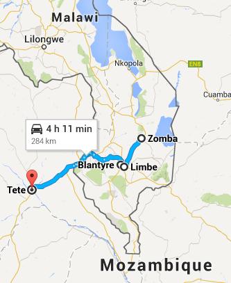
[Source: Map data ©2014 AfriGIS (Pty) Ltd, Google]
The first leg of the route to Liwonde is very boring. Although it follows the lake shore closely, it is too low to be able to see it. As soon as the Shire river is crossed, things change for the better.
The landscape starts undulating and the road winds along various hills. Very scenic.
Upon our arrival at Zomba we went straight up to the plateau. This is a great road – reminiscent of Chapman’s Peak with sweeping bends and provides great views of the valley below, until entering the cloud base. The cloud base would normally not be this low, but it had started raining that morning, and was sporadically to continue so for the next 4 days, until we crossed back into South Africa.
We intended staying at the Trout Farm Chalets, but these were not available. The Sunbird Hotel franchise has accommodation all over Malawi – also here at the Ku Chawe Inn – but these are decidedly upmarket establishments, which is why we always avoided staying here.
So down the pass we went again, in the meantime telephonically getting hold of Annie of Annie’s Lodge fame in Zomba. She could not accommodate us all in town, and agreed to meet us a few kms out of town at an establishment called Black Diamond.

This turned out to be a disco-type clubbing establishment with loud music playing – but likeable Reggae. Mmmmm.
A short while later, the Black Diamond herself arrived in a top-of-the-line Range Rover. One notices these things as it contrasts wildly with any other transport we have seen to date, including that of tourists from better-off places.
Annie showed us the available accommodation – 3 chalets off to one side of the dancing hall and a house separated only by a farm road from the hall. As we could securely park our cars and all fit into the house – which was still in the process of being renovated – we took this option.
After our resident negotiator argued her price down to what she had originally quoted over the phone – it had crept up a bracket or two since then – we started unpacking and moving in.
The accommodation was OK, The fridge was on and the stove worked – the plates could not be switched off other than at the mains switch on the wall, though. The rooms were strangely – almost randomly – scattered throughout the house. Three of them were ensuite, although not everyone had hot water, or for that matter even a hot tap – ours was broken off the sink.
So we could cook, get cleaned up and sleep, which was all we needed. But we could not shake off this nagging feeling that somehow this house is one of those that the Animals sang about in a song with words that start like this: “There is – a house – in New Orleans, they call….” etc. Especially after the children found some used evidence to this effect in one of the rooms.
So the next day we were off early via Blantyre – which has a well-stocked Shoprite-anchored mall. Then onwards towards the border post at Zobue.
Other than getting flustered by the annoying swamping of the money changers offering Meticals for Kwachas, this was the only place where we were subjected to an incident which left a bit of a sour taste in our mouths. Up to that point, we had not come across any criminal element, or even felt threatened, anywhere during our travels – we left those people behind when we crossed the border.
Returning to our cars on the Malawi side after going through immigration, a local was leaning against the front of the Freelander with his back towards us. When he saw us coming round the back of the car, he sidled around the front and came up to me suggesting that I reward him for his efforts of looking after my car so nicely. I declined his offer.
This guy could however not take no for an answer, and kept following us around even after we were already in the car – walking next to us as we rolled towards the exit boom.
By this time his insistence that he deserved a fee, had escalated to arrogance. But WHY not? I finally explained to him that as I had not asked him to look after my car – he was not even there when we parked – I was not going to reward him.
We thought nothing of this until later that afternoon when we stopped at Tete, where we were staying the night.
While we were unpacking, someone noticed that except for one, all the stick-on reflectors – that I put on especially for Mozambique – were missing from the car. They were still there very recently – a photo of the car the previous night shows them all to be present.
On closer inspection of Adriaan’s car – who was parked next to me at the border post – his was also all missing, with just remnants of the double-sided tape remaining. Armas had also lost one off his trailer.
From this we learnt that it is better to rather use the reflective white and red stickers, which can be bought widely at home. This is not so desirable an item as those rectangular reflectors. What does he want to do with it? Stick it on his bike, or maybe put dots on them so he has a white and red set of dominoes?
Fortunately, we could restore the Freelander to “Moz legal” as a number of spare reflectors had been brought along just in case one fell off.
But I hope someone catches that Malawian “car guard” in the act real soon, and twists his ear a bit. If this privilege befalls YOU, please say “Hi” from us.
At Tete we also came super close to a second traffic fine – but not for speeding. The bridge off-ramp on the northern side is constructed as an under-pass. So you turn left at the end of the bridge and then drive underneath it to get onto the road leading along the …
Day trip – Boland and Klein Karoo
Well, actually a two-day trip.

[Source: Map data ©2014 AfriGIS (Pty) Ltd, Google]
Franschhoek
We set out for Montagu on the Saturday morning and decided to go have a look what’s happening at Franschhoek.
On this morning Franschhoek sported French names, French restaurants, French flags, French berets, French rugby or soccer jerseys, pretty much everything French but French itself. Or maybe there might have been a few Francophones, I just haven’t heard any of them. The reason for this French extravagance was the Bastille Festival held over two days.
The history of Franschhoek dates back to the revocation of the Edict of Nantes in France in 1685 in terms whereof Protestantism was outlawed. Some 277 Huguenots fled France, and were given land by the Dutch government in the Cape after their arrival there.
Once a year Franschhoek celebrates the Bastille Festival . And this was that weekend. [Vir ‘n effense ander blik op hierdie uitstappie in Afrikaans.]
We were fortunate to arrive early enough to get a nice seat at a side-walk café to have a morning coffee. The athmosphere was festive.

Being en route to another destination we did not spend much time here. Better luck next year. We’ve been there long enough, though, to sit and watch the first marching band coming through town, right in front of us.

Taking some back roads we managed to escape a by then rather busy town to go over the Franschhoek pass, leading to Villiersdorp. Franschhoek makes a wonderful sight looking down from the pass.

Outside Robertson is the Affieplaas Padstal. For years I have driven past this road stall, but never got around to stopping to take a picture of these blokes. Today I had time.

McGregor
Next destination, McGregor. The area drew the first farmers in the late 1700’s. Only in 1862 was a town proclaimed and by 1905 all plots had been sold to 19 owners. The town is pretty much a road to nowhere, so there is no traffic passing through.
Arriving at McGregor we tried to get a bit of a feel for the town. I found the corner of the town (literally).

This was an elevated spot from which I could overlook downtown McGregor.

From there we moved on for lunch at Tebaldi’s. The restaurant is situated in a part of town where the whole block appears to have been converted in a sanctuary where you can do meditation, swim, eat, stay over, or do whatever peaceful activity takes your fancy.
The street lamps struck me.

The town was very quiet. I did notice, though, that the police appears to be actively keeping it that way with the patrol van doing its rounds probably twice in the time we were there. I do not believe they would establish an emergency response unit for this town soon.
After lunch we took the road back to Robertson as we came. I noticed that Robertson also advertises their “Slow Festival” coming up soon. It is a food and wine festival with the catch phrase “slowly made, slowly enjoyed”. Well, I guess any excuse for a festival should do.
Montagu
Our destination was Montagu. We visit there often, but this was the first time we stayed in a guest house in town.
Aasvoëlkrans offered rather nice accommodation.

Our suite overlooking a horse pen.


Judging from the guest book it will appear that a great many German tourits find their way to this guest house.
A great breather of a weekend, within 180km’s of home.…
Vleesbaai 4×4
By PG & Johnie Jonker
It was a clear sunny December morning when we arrived at the Vleesbaai 4×4 route for a bit of dune driving. Whilst doing the preliminaries more vehicles arrived.
Eventually 7 vehicles set out on the route, following the Colt DC (petrol) leader vehicle. I was a passenger in bro’ Johnie’s Tiguan.
At the first real dune those who still not had their tyres deflated did so.

Being a bit of a techno-freak bro’ Johnie made an adaptor that could keep his camera in position on the roof of the Tiguan to get some good video clips.

The first obstacle was a steepish dune that required some speed to make it over the top, but over rather uneven ground. This somehow caused the Pajero’s cowl to become unstuck. Fortunately the handy guys in the crowd could get things up and running in no time.
In the meantime the rest of the crowd was getting the hang of things, rushing up and down the dune. One of the drivers got a bit carried away with his Discovery V8. He enjoyed himself so much that he sommer came back the way he went – forgetting that this would but him right in harm’s way of someone charging up the blind hill of the dune! Fortunately no harm done.
However, shortly thereafter I noticed steam coming from underneath the bonnet of the V8, so I’m not quite sure that no harm was done there.
I thought the Tiguan was doing rather splendid given its demeanour as a bit of a town’s car, rather than a serious off roader.

Some of the obstacles proved too much for most of the vehicles. At one of the dunes only the lead vehicle and the next vehicle could make it to the top. None of the rest could, although not due to lack of trying. It made for some spectacular viewing.
Only one vehicle did not attempt the obstacle. The gentleman with a Touareg told me that he had a few thousand Rands worth of repairs done to his vehicle after he damaged it on that exact obstacle only a few weeks earlier.
At this stage I was having my doubts about the Drive Out Magazine’s difficulty rating of only 2 – 3. Watching, and listening to some of the laborious efforts of the engines of some of the vehicles, I thought it might warrant a slightly higher rating. But then again, I’m not really into heavy off-roading, so maybe it’s just me.
Now just for the sake of perspective I have to insert this picture.

The angle is not quite correct, but picture you’re travelling slowly down a dune, minding your own business. In front of you is this Defender. The gap between the Tiguan and the Defender is becoming smaller at an uncomfortable constant speed. The reason being that, although we are only driving at 30km/h, the Defender is doing 25km/h.
This should really not be a problem. I mean, as is the custom, the Tiguan is fitted with brakes. So the application of this fairly basic bit of technology should solve the problem.
Not so.
I will let Johnie take up the story from here, as it becomes slightly technical.
“My VW Tiguan suffered considerable front-end damage due to the failure of the ABS system to stop the car, resulting into tailgating the vehicle ahead of me. Although the brake pedal was depressed, gently initially but with more force [it went along with some verbal encouragement as well – PGJ] when I realised the car’s braking was ineffective, the only response was the continuous kicking of the pedal under my foot for the time it took to run into the vehicle ahead.
This specific part of the route was a gently winding descent on a sand road – not overly loose, at trailing throttle – the vehicle in front was probably travelling at 25 km/h and the Tiguan at 30 km/h at the moment of impact.
The top of the bonnet was crushed by the rear door mounted spare wheel of a Landrover Defender 110, which did not suffer any damage. [So now we know why it is called a Defender. The gentleman in the Defender was unaware even of the impact! – PGJ]
Once the radiator had been clipped back into position to stop the cooling fan wearing away the broken air inlet ducting and makeshift repairs were made to enable the bonnet to latch, we travelled further.
The problem appeared to be the ESP. As the ESP resets itself to ON every time the ignition is switched off, it is required to disable it before starting off each time. This was diligently done for the preceding 20 engine starts, except for this one, seeing that it was going to be downhill all the way on a relatively solid sand road. Tyres were deflated to 0.8 bar, giving a good footprint/grip on the surface.
Following the collision, I decided to verify whether the situation could be simulated or whether it was a once-off occurrence. On the return path to the route start, I reversed downhill over the same route with ESP ON, and then applied the brakes, with the same result – the pedal just kicking under my foot – this time stopping the car with the parking brake.
I then disabled the ESP, repeated the same exercise, and the car stopped immediately.”
In any event, the sensation of sitting and watching in slow motion how you hit the car in front of you is a riveting experience, although not necessarily one that one would like to have a repeat of.
The result of the impact on the Tiguan was as follows:

After a bit of tinkering on the car back at the Gouritsmond Caravan Park it looked like this.

Not quite as be fore, but at least the bonnet could close again properly. After a subsequent visit to the panel beaters it was restored to its former glory, which looked even better.
So, lesson learnt: when driving off roading in a car with all sorts of high tech gizmos, maybe it’s best to get out and take pictures from a distance?
Alternatively, RTFM [read the freaking manual] beforehand.
PGJ…
Namaqua National Park – Part 1
Or: how PG got his groove
By PG Jonker
[Extracts hereof published in Leisure Wheels, July 2011]
“Kamieskroon? Ja, sure, I know Kamieskroon.”
Well, I don’t really know Kamieskroon. It’s more like the way you know the Tooth Fairy and Santa Clause. You sort of know them, you just never met them.
Anyway, to cut things short, we were invited to join a crowd already existing of 5 vehicles to an outing to the Namaqua National Park and the Spoeg river caves. The rendezvous point would be Kamieskroon.
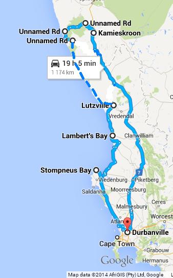
[Source: Map data ©2014 AfriGIS (Pty) Ltd, Google]
Preliminaries
Now, before our date of departure I had to attend to a few things on my bakkie. More in particular, for quite a while the bakkie had been teasing me with a “hoi!” when commanded to start the engine. Invariably on a second attempt, the engine would start. However, this is clearly not the way the engine was designed to operate, and I thought it would be rather unsportsmanlike to proceed on the trip with what appears to be a pending hassle. I might bog down the whole group in a difficult situation in sand.
The auto electrician where I took it to replace the battery advised that it was not the battery, but the alternator. They did not have time to rebuild it before the weekend, so I settled for a replacement alternator.
However, shortly after taking delivery of my fixed vehicle I was merrily greeted again with a “hoi!” from the engine compartment. I called the auto-lec, but he assured me that I must just give the new alternator a chance to properly charge the battery.
On the road again
So on the Friday afternoon of a long weekend in March we left Durbanville in 36 degrees Centigrade. Upon later reflection this accounted for a cooler part of the weekend.
Just before Citrusdal we had to stop at road works. Upon restarting the bakkie, it said “hoi!”
I thought: “$%^&!”, but said nothing – just smiled at my wife. She later advised that she would prefer that I do not smile at her like that.
Shortly after that, just about 100m before the turn-off into Citrusdal, I noticed the battery light coming on. I then realised what that faintly familiar sounding clonking sounds were that I heard from underneath the bonnet shortly before that. As a best case scenario my fan belt broke. Worst case scenario, the new alternator departed.
I turned into Citrusdal. It was 17h15 on the Friday afternoon that marked the beginning of a long weekend.
Engine problems
The first building to be found in Citrusdal turned out to be the Toyota garage. With the bakkie’s temperature needle reaching for the upper quarter of the gauge I coasted to a halt in front of the (open!) doors of the part of the building that read: “Service Centre”.

I opened the bonnet and saw the remaining strings of my fan belt stuck around the new alternator.
A very friendly JP Visagie came out to see what the problem was. JP is a big chap. I would assume he will make a good lock forward for the local rugby team if they can work up his aggression levels a bit. Having successfully identified the engine and alternator to him, he had me pull the bakkie into the workshop, and set to work. It turned out that my new alternator is of a different type than the previous one, which necessitated a different length of fan belt. The new fan belt might have been either too thin or too loose, and got chewed up by the alternator. Also, the second belt had a 180 degrees twist in it.

JP had to experiment with pretty much half of the fan belts they had in stock to get one that could serve as the now non-standard fan belt. I bought an additional one of those (for the past 10 years I’ve had spares of all three belts in my bakkie, never having any use for them).
A half an hour later the bakkie was up and running again. Pieter & Hanneke Loots have since learnt of our problems and called to say they are waiting for us at Klawer until we got there. I suggested they rather not do so, but Pieter assured me that he had nothing better to do than to sit in the Wimpy at the garage and sip some coffee – which, incidentally, is served virtually by the gallon by that specific outlet. We arrived there some time after dark, and travelled in convoy further.
It was the night before the super full moon of 19 March 2011, and we had a very full moon shining.

We were the last two vehicles of the crowd to arrive at the Gousblom B & B at Kamieskroon at 21h30.

It was a happy crowd. We were introduced to each other, had a braai, and eventually settled down to sleep in air conditioned(!) rooms. The nineteen people easily fitted into the guest house, with even some rooms unoccupied.
Departure
We awoke and started doing breakfast / packing at a very sedate pace on Saturday morning. No-one was in a hurry. This is actually nice. It puts a bit of pressure on those without trailers and tray systems and the like to keep up with a fast moving crowd.

After a last stop at the Kamieskroon petrol station we left Kamieskroon at 09h00.

We took the gravel road that leads past the Kamieskroon Hotel into the Namakwa National Park.

The line-up
The full complement of the tour group consisted of 6 vehicles and 19 people. The vehicle line-up was:
- Land Rover Defender Td5 with trailer. Martin Behm, tour leader, at the helm, with his son Daniel.
- Current generation Hilux double cab. Koos & Surita Janse van Rensburg and their sons Janco and Wikus.
- Previous generation Hilux double cab. Johan & Celia van der Merwe (oupa & ouma).
- Mazda 3.4 double cab. PG & Marga Jonker with Anita and Chris-Jan.
- Toyota Fortuner with trailer. Pieter & Hanneke Loots, with their sons André and Hanro.
- A 2×4 Colt cab-and-a-half. Thomas & Marinka Swanepoel with their daughter Tayla.
 …
…
Namaqua National Park – Part 2
[Continued from Part 1]
The Park
The Namaqua National Park Park is still in a development phase, and there is still active farming activities going on there. This will apparently be phased out over time.
Quiver trees abound. Some Maartblomme were visible. At the bookings office there were marked succulents like Taaibos and Kukemakranka (so there’s genuinely such a plant)!

After registering at the Skilpad office, Namaqua National Park (S30°09.489’; E017°46.29’), Martin led the way on the Caracal Eco Route. Each vehicle received a booklet in which the routes are marked. Without that I can imagine you can easily get lost in the Park! Turning points on the route are marked with Caracal signs, some of which are numbered to enable you to plot yourself on the map in the booklet.

After visiting the first view point we descended down the Kamiesberg mountains on a cement road. The road then became a typical tweespoor farm track on hard ground. Old ruins are to be found where there used to be permanent settlements.

At the Witboois river we turned off, rather than to head for Soebatsfontein. Martin chose the detour that would eventually take us over the Wildeperdehoek pass.
By now we have seen quite a number of Gemsbok and Springbok, and also a solitary Hartebeest. In spite of the office bearing the name Skilpad, I’ve only seen one dead turtle. Which is probably a good reason to preserve them. The area is apparently frequented by leopard, with camera traps set to get pictures of them.
The road remained pretty much what you would expect on a farm road.
Before the Wildeperdehoek pass there is one very steep incline where low range is convenient to get up there slowly. It is not essential, though, as Thomas’ endeavours with his 2×4 Colt would attest to. The Colt went up the incline with no apparent strain.
It appeared that my bakkie’s starting problem was more acute when the engine was hot. By now, every time we stopped I would first get the now standard “hoi”, before the engine would fire up at the next attempt. I became reluctant to switch off my engine. However, by now the outside temperature had gone up to 49 degrees. Letting the bakkie idle soon saw the temperature needle climbing. From previous experience I knew that my viscous fan only kicks in once the red line is reached. I’m not inclined to wait that long, though, and previously had a separate switched connected to the air conditioner’s fan so that I can activate this manually, while keeping the air conditioner off. This worked well.
Wildeperdehoek pass
We turned left for the Wildeperdehoek pass (S29°56.319’; E017°38.085’). From the Parks’ office to the Wildeperdehoek pass it took some three-and-quarter hours travel. The tweespoor becomes a proper road that takes you over the pass.

The pass was built in similar fashion that the Bain’s passes. It was constructed in the late 1800’s for transporting copper ore from Springbok to Hondeklip Bay.
From the pass you look down on a grass plain to the West which is apparently one of the few grassy areas in Namaqua. In the distance below you can also see the two gravel roads that runs to Koingnaas and Soebatsfontein respectively.
Reaching the bottom of the pass we took the road to Koingnaas. This is a gravel highway, as opposed to the twee spoor tracks that we had been doing up to that point. At the next split in the road (S30°06.691’; E017°24.781’) we aimed south.

Somehow, however, we took a wrong road (I kid you not).
Car trouble (again)
Fiddling with my GPS I went through a pothole that caused my number plate to come loose. As the convoy had to turn around to get to the correct road, however, Martin saw it before I lost my number plate completely. The convoy was in any event brought to a grinding halt with a stick puncturing the sidewall on Koos’ Hilux.

Once again, it was a merry crowd. Out came the tray systems and cooler boxes, with refreshments readily at hand whilst advising Koos on plugging the puncture. It is unlikely that Koos will ever again have so many advisers on the issue of plugging a puncture. Koos did the job with aplomb, and soon we were underway again.
I was parked slightly out of the way, and could quietly seek the assistance of a more practical member of the convoy to assist me with what was supposed to be the fairly simple task of getting my number plate affixed to my bumper again.

With everyone fixed up again we found ourselves south bound, again on a twee spoor track.

Sanpark’s booklet describes the area as having rare arid fynbos elements, with pin cushions to be found on the dunes.
[ Part 3 to follow]…
Namaqua National Park – Part 3
By PG Jonker
[Continued from Part 2]
Coastal part of the Park
We eventually crossed the main gravel road between Hondeklipbaai and Garies, with gates on both sides of the road to be closed (S30°21.195’;E017°25.569’). We were now heading for the coastal part of the preservation area.
This area is one of the few unspoilt sections of Namaqua Coastal Duneveld left.
Shortly before 16h00 the afternoon we took the turn-off (S30°29.031’; E017°23.731’)to the Spoeg River caves. The road became very sandy. Although we let our tyres down a bit for the gravel road when we entered the Namaqua Park, our tyres were over inflated for sandy conditions. Although I was in 4×4 I could feel the bakkie doing battle to remain on top of the sand. Shortly thereafter Thomas’ Colt 2×4 became stuck. He was actually doing rather well up to that point, but as the going speed was too slow, he got stuck.

Fortunately the 49 degrees of earlier today had by then dropped down considerably, with a cool wind blowing in from the sea.
The Colt was pulled out easily enough with the use of a fixed rope (not a kinetic strap), but became stuck again only a few meters on. We now all let down our tyres to 1.2 kPa, the Colt down to 1kPa. The Colt was then pulled out to the next hard section where our convoy had to wait to make way for another convoy returning from the caves.
Here things nearly unravelled due to some miscommunication. Martin was advised by the returning convoy that it is downhill to the caves, and that they did battle to make it back up the hill with the thick sand. Given the Colt’s impediment Martin considered it better to rather not proceed down to the caves. However, it turned out that only the guy towing a heavy off road caravan had some difficulties getting up the slope. So once this convoy went past, we travelled the last half-a kilometre to the caves, leaving the Colt (but not its passengers) behind.
Spoeg river caves
The caves are something rather special (S30°28.310’; E017°22.194’).
 The site also has the archaeological importance that signs of sheep farming dating back some 2000 years had been found there. It is believed that the cave had been used by the Khoi-Khoi as they migrated South with their flock.

For the only time on the tour a sense of urgency seemed prevailed to get moving. It was now almost 17h30 in the afternoon, and we still had quite a bit to go before we would get to a place where we could make camp.
This is a place where one should spent quite a bit of time, but then again, maybe on your own, to enjoy the absolute quiet and atmosphere.
Dunefeld
We were now south bound, heading for the Groen river mouth. It was clear, however, that we would not make it that far that evening.
Just before 18h00 we reached a notice that said “Soft sand 4×4 only”.

Shortly thereafter the lead vehicle became stuck in the sand. Towing a trailer, things were slightly more complicated for Martin in his Landrover.

With a little push from the rest of us Martin reversed the Land Rover out of the thick sand, and tried again, this time with a bit more momentum. No problem this time.
The trick now, of course, was to get the Colt 2×4 through the thick sand. Two words. Speed and momentum. OK, three words. Speed, momentum and balls. Thomas engaged his diff lock and flew off with the Colt after making sure that the coast was clear. Rather amazing he came through without getting stuck.
However, the worse was still to come. The next difficult section required negotiating an uphill sand track. This proved too much for the Colt, and it got bogged down.

Three vehicles have past, three were left.
Making a plan
Being stranded uphill, the converse is of course now true. To tow the Colt out would mean a downhill endeavour. How difficult could that now be? I reversed my bakkie up to where the Colt was stuck. The tow rope was hitched and I pulled the Colt out. Uhm…. well, actually, not exactly. I got stuck myself.
I assume that:
(a) I left the diff lock for too late, and that it in fact did not engage, and
(b) I probably tried too quickly, bogging my bakkie down, instead of pulling us both clear.
With some assistance I managed to extract myself from the sand again. Now, I love these handy guys that always seem to have a plan. Pieter, appearing very happy to get a shot at pulling the Colt free, came jogging past me. “We’re going to make a plan now.”
Friends of mine from the UK always find this a peculiar expression. Apparently the Brits arrange stuff. Not South Africans. No, we make a plan. But I digress. I’m not sure whether Pieter had any plan other than to simply hitch the Colt to his Fortuner and to pull it out with brute force. This is exactly what he did.
But now things called for some plan making. What do we do now? Do we camp right there and make a plan tomorrow? Do we turn around? Or do we proceed. It was decided to proceed. Pieter would hitch the Colt, and they will then drive in tandem through the next stretch of road. Those who already did that stretch of road felt that, if the Colt got through, albeit Colt-on-a-rope, there cannot possibly be any more daunting obstacles that would prevent the Colt from making it the rest of the trip.
Smile and wave, boys, smile and wave
What followed could best be described through the eyes of Pieter’s grade 8 son.
“Oom, my dad was behind the wheel of the Fortuner, chatting with oom Martin sitting next to him, and gave me the thumbs up as he went past. Oom Thomas was clinging to the Colt’s steering wheel, concentrating on the road, with Oupa sitting next to him and hanging onto the grab handle with both hands. In the back of the Colt Oom Koos had the tarpaulin folded away and was sitting there, all smiles, waving at us …
Namaqua National Park – Part 4
By PG Jonker
[Continued from Part 3]
Groen rivier
The next morning we took our time to get uncamped again. We made sure that we took everything with us that we brought in, and by 09h45 we were on our way again.
The temperature remained some 21 degrees. With the fog of the previous evening, the thick sand was now much easier to negotiate. It still was a very impressive sight to see Thomas in his Colt flying off, after giving the vehicle in front of him some space, never to get stuck in spite of long stretches of very thick sand.
At one point, though, there was a sharp bend in the road, with rocks in the sand. Obviously you do not want to do that with speed, as such a rock can do some damage to your vehicle. So as a precaution the Colt was hitched to one of the vehicles to enable him to negotiate this bend at a more sedate speed.
The problem with getting involved in the action is that you tend to forget about pictures. By the time we realised that we should actually take a few pictures of the Colt in full cry, most of the thick sand parts were behind us. However, at the next stretch my wife made a point of taking pictures. But this happens on the move. The result is a picture of the blue sky, one of the bakkie’s bonnet, another of the sand tracks in front of us, all blurry. So we were not as successful as we would have wished to be in getting evidence of Thomas’ feat.

The sand tracks run right next to the sea. Various basic areas of ablution had been set up by the Parks authority, offering you a long drop and some rocky walls that give shelter against wind.

Just before noon we reached the Groen river mouth (S30°49.751’; E017°34.950’). It’s actually an estuary that is only occasionally opened by wave action, when sea water would flood the estuary. As the water evaporates, it leaves the salt behind, making it one of the saltiest on the South African coast.

It was nevertheless a good time to do lunch.
We left, taking the road past the Groen river light house.

There were still a few sandy stretches left, but none of those appeared daunting any more. By about 15h00 we hit the tar road again, heading for Lutzville.
We were driving slowly, as our tyres were still under-inflated for the sand. About 40 km’s before Lutzville Koos’ patched up tyre blew out its last wind, necessitating a stop to change wheels. It was then that Koos realised that, following a recent rear end bump, he never checked whether he could reach the spare wheel underneath his Hilux. It turned out that he could. Not that it would have made much of a difference – between the remaining vehicles (three of us remained with Koos) we had sufficient spare wheels to help him out).
Strandfontein
After filling up at Lutzville and inflating our tyres we headed for nearby Strandfontein. And what an amazing place it turned out to be.
We were allocated camp sites in the ‘horse shoe’ part of the Municipal camping site. Before our arrival there was only one vehicle there. The lower camp site overlooking the sea, though, appeared to be fully occupied.

The weather was absolutely perfect. Slightly overcast, windless, quiet (save for us, that is).
We ended the weekend with a potjiekos competition. The options to choose from were sheep, chicken, bread (two variants) and chocolate cake (true). After much deliberation we decided it was a draw.
A perfect end to a wonderful weekend.
In the groove, babe
Now, there is a malicious rumour going around that I don’t have the balls to do heavy 4×4 stuff. So let me be clear on this. This rumour is absolutely true. But this tour, I would say, falls squarely within what I find extremely palatable.
So maybe one can say I’ve got my groove….
Statistics
Distances:
Day 1: Cape Town to Kamieskroon 481km’s
Day 2: Kamieskroon to West Coast 180km’s
Day 3: From overnight to Strandfontein 198km’s
Day 4: Strandfontein to home 339km’s (via St Helena Bay)
Total distance travelled: 1 198km’s
Distance on gravel and 4×4: 290km’s
Fuel consumption – best: 7,4km/l
Fuel consumption – worst: 5,2km/l
Fuel consumption – average: 6,3km/l
To consider before my next trip
Get the starting problem on the bakkie fixed – nope: been there, done that, no cure – that in itself is another story
Consider a fixed fan instead of a viscous one – nope: been advised that this is not a good plan; noisy, uneconomical, and apparently causes uneven temperature in engine
Check whether the diff lock is in fact working – now there’s a good idea.
Get some balls. The kids love playing with balls.
To read:
http://www.sanparks.org/parks/namaqua/tourism/caracal_eco_route.php
Booklet: Caracal Eco Route – Namaqua National Park
PG JONKER…
In the shadows of Table Mountain

At the upper end of the Gardens is the Iziko Museum.

Chipmunks and doves abound. The doves’ sanitation arrangements pose a bit of a problem at times. Fortunately chipmunks cannot fly.

Nearby is the old Green Market Square, surrounded by old buildings from the colonial era – and a few newer ones.

Colours for Africa


Sculptures.

And for good measure, a quick visit to the new Cape Town stadion, with some supporters showing their colours for the Soccer World Cup – a bit late, though.
 …
…
Magic Klein Karoo
On a farm outside Montagu.
It is a mountainous area, with magnificent views.

Other things also amuses small minds.


Water is sourced from a natural spring. Pretty remote, and it takes some planning to get to the spring. So the farmer decided to make a road to get there.
Not quite your ordinary road. And albeit a road, it would be life threatening traversing it with a vehicle without low range.

The road takes you down into a ravine.
Here water comes from a rock. Unlike Moses there is no need to hit the rock. You just scrape away the moss, and out comes the water.

From there you walk a distance to get to the spring. Well, not really to the spring, but to a pool into which the spring deposits its water.
On your way there you find some interesting rock formations.

And more.

Looking back.

And then you find this pool between the rocks. At the far end where the water comes in, moss has made it a slippery slide. Once you let go, you have no control. Gravity takes over.

Careful, grandpa, let me hold your hand.

And then back up again.
 …
…