Port Nolloth
We headed out on a drive to Port Nolloth recently. It is a leisurely 700k drive from Cape Town.

The town itself is not big, and, well, desertish one could say.

When copper was discovered in 1852 at nearby O’Kiep (ok, 160km is ‘nearby’ in this part of the world) the then Cape Colony administration decided to develop Port Nolloth as a port for the export of copper.
However, the harbour was too shallow for bigger ships, with some resulting losses / repairs, and by the early 1900’s they started sending O’Kiep’s copper via rail to a different destination for export. In 1926, though, Port Nolloth was revived when alluvial diamonds were found. [Source: Port Nolloth – Wikipedia]
The most recent sensus figures of 2011 show the population of Port Nolloth as 11 982. [Source: Richtersveld Local Municipality – Wikipedia]


A tour within a tour
Since we were in the vicinity, we decided we should explore the Southerly neighbouring towns.

Our travels took us first to Kleinzee, some 70 km’s South of Port Nolloth. Kleinzee used to be a closed diamond town with, at its peak, some 4000 inhabitants. Mining came to an end by 2013 with the town now being ‘open’, but evidently with very scaled down economic activity.
Interestingly, whereas the road from Port Nolloth to Kleinzee is a gravel road, between Kleinzee and Koingnaas the road is tarred. Koingnaas was established in 1970 as a satellite town of Kleinzee, and the same fate thus befell it as Kleinzee when mining activities came to an end. I would assume De Beers, who did the mining explorations, had the road tarred for the benefit of the people living in these two towns. The population in 2011 was 728 and, well, it shows.
The last remaining town on our day trip was Hondeklipbaai (Dog stone bay, directly translated). Population 540.

A local with whom we chatted explained that with the demise of the mining activities, and also with the fishing factory closing down, the town basically ground to a halt. It is, well, small and quiet.
The name comes from a stone that looks like a dog. Viewing a picture of this stone, I could not make out the dog, so I skipped the 4km drive to check out the stone for myself. Sorry. We rather had lunch at Sam’s.


From Hondeklipbaai you can aim to the East the 94km to Garies, or back North to Port Nolloth 157km away. After lunch at Sam’s Restaurant, we headed back for Port Nolloth.
In the week before our visit a storm dislodged the bell buoy in the harbour from its mooring and they had to send a tug after it to chase it down and bring it back.

What follows is a summary for dummies on navigation in Port Nolloth harbour. I found it fascinating.
The recalcitrant bell buoy is some 12 meters in height. The upper 4 meter structure houses the bell which rings as the swell causes the buoy to move in the water – for the foggy days when you have to listen for the bell because you cannot see it. The buoy itself is another 4 meters, and the part below the water also 4 meters. This buoy needs to be anchored to two moorings, and held in position which is indicated on the nautical navigational maps. Given the purpose it serves, only a very small margin of movement is allowed.
So the traveller approaching Port Nolloth first needs to line up (at 066 degrees) the lighthouse, the leading light (which is about 40 meters in front of it) and the light on the bell buoy.
You then navigate your boat to the bell buoy at 66 degrees. Once past the bell buoy, the aim to the right where there is a designated channel through which you should travel. This is demarcated by three red buoys on the port side (left) and three green buoys on the starboard side. Once through this channel there is a further series of yellow buoys just to keep you on track up to the jetty.

Since I take it that the discerned readers of this blog were just dying to know how to navigate into Port Nolloth harbour, I inserted the part above specially for you.


De Hoop Whale Trail – Part 1
Arrival and day 1
Intro
“We’re going to do the Wales thing,” said my wife one day.
“Oh, good. We’ll need visas.”
“No. Whales, not Wales,” said she.
“Oh, good. I like whales.”
“We’re going on a 5-day hike.”
“Oooh…..,” said I.
And so it came to pass that we arrived at the De Hoop Nature Reserve close to Swellendam on a Saturday afternoon to join a team which totalled 9 people. We did not take up the full capacity of 12 people that can take up a block booking.
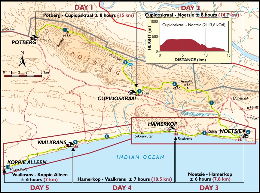
The De Hoop Nature Reserve lies between the Denel Overberg testing site, and the mouth of the Breede river. Just over three hours’ travel from Cape Town, regardless of whether you go via the N2 through Caledon, or the N1 via Swellendam. Just to get your bearings on where it is, Cape Nature provides this map:

De Hoop is one of Africa’s biggest conservation areas, and access is fairly exclusive. You need to be on the Whale Trail hike, it seems, to get access to this bit of nature.
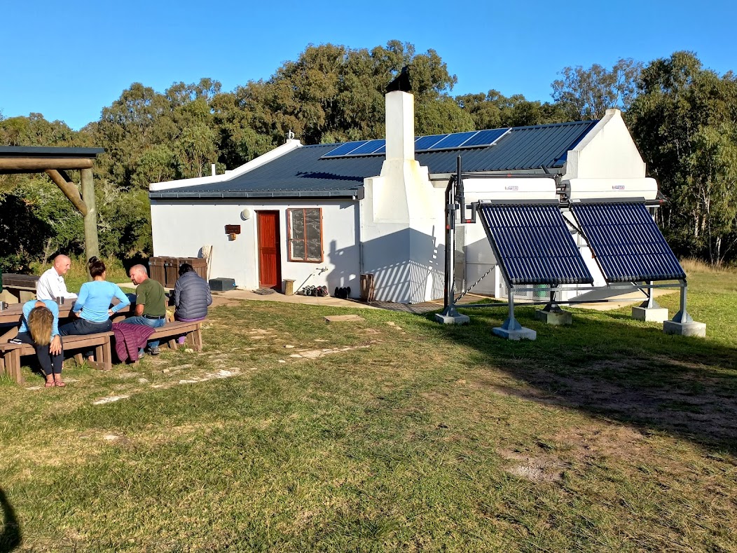
The trail offers accommodation in huts with running water, sun-powered electricity, a fully kitted kitchen, and sleeping bunks for 12 people, typically spread over three rooms. It also has inside and outside braais at each location. We opted for the slack pack option (slapgatstap?) where we made use of a 70 litre box each, and with 2 cooler boxes available per group, which is transported by officials from hut to hut. So we only needed to carry a day pack each day. We arrived at the Potberg Hut from where we would depart the following morning. After meeting the rest of our group, we moved over the main building to receive a fairly extensive briefing.

I missed a lot of what was said (it’s not the presenter’s problem that I cannot hear properly), but I did pick up the bit about the 45 stompies wood at each hut for our use. Something we dutifully obliged each night to follow.
Back at the Potberg Hut we sorted out the sleeping arrangements.

There were two rooms downstairs, and one room up in the loft. From my bed upstairs I had a view of the Potberg, which we would summit the following morning.

This was the only hut with outside ablution. So going for a nocturnal see-a-man-about-a-dog, meant walking over the creaking wooden floor, traverse very steep stairs (no, a ladder) going down, which brings you in the next room, then through the kitchen, and then to the outside ablution. It’s amazing what motivation can do to bladder control.
Each made their own food, but we did braai (no, really) together. We also got to know the team. I was delighted to learn that two members of the team were seasoned mountaineers, with one of them actively participating in Mountain Rescue. This being my maiden hike, I found great comfort in this news. Whoopeee! We’re gonna be saved.
It is amazing how much brighter stars are where there is no superficial light. We spent some time admiring the stars and finding the Southern Cross and Orion. Those are the only two constellations I can ever find, and I’m very proud of myself.
During the night I noticed two massive spotlights through the window of our room. I assumed it is the Musk dude being up to some mischief, but I was later advised that this was actually the Jupiter and Venus conjunction.
Day 1: Potberg Hut to Cupidoskraal
According to the map provided, this hike would be “15.5 km – difficult approx. 8 hours”. We left just before 9 the morning.
The route set off with a steep climb up to the top of the Potberg where a radio repeater marks the 611m highest point. By the time we got there we have covered some 4.5 km in 1h40 minutes. A leisurely pace.

From this point one has a 360-degree view. To the north one can see the Breede River and Malgas, with Witsand to the east, and the Indian ocean to the south of us.

We had a snack break here, enjoying the scenery and watching the Cape Vultures circling above. It did concern me that they were circling us already. I mean, really.
After snacks we started our descent down into Grootkloof, where Erica and Protea species are found that grow nowhere else in the world. I’m not sure if this is one of those, but it is still a marvellous plant.

We had a nice long downhill walk to the Melkhout River. When I had a look at the map before departure, I pictured us wading hip deep through a raging river, so I came prepared carrying my water friendly sandals along for the occasion. Only to find that someone built a proper wooden bridge across the river. Paaah!
We had lunch at the Melkhout River. By now some natural selection started to develop with people sticking together with those whose pace suited them better than others’. The get-up-and-go for the final stretch was, for instance, the cue for one member to instead start up his mini gas plate to brew some coffee. I decided to feint concern for him and hung back. (Chinese saying: Never let a good coffee opportunity go to waste. OK, I’m lying, I made that one up, but I’m sure the Chinese wise people would agree.)
We did take care, though for the party not to become too stretched out. At that point there was some 4km’s left of the route, and we soon afterwards joined the next two team members forming the rear-guard. Oh, and the coffee was good, yes, thank you for asking.
And then, after 15,5 km’s, we arrived at Cupidoskraal at 16h00.
For part two, click on link below. …
The Whale Trail Hike – Part 2
Day 2 & 3
Day 2: Cupidoskraal to Noetsie
According to the map provided, this hike would be “15.2 km – moderate approx. 8 hours”.
Cape Nature’s map:
We did an earlier start at 08h00. We left behind the containers to be collected and taken to our next destination. I must say, I’m not sure how you do a five day hike carrying all those stuff plus foodstuffs along.
This route also started with a very steep incline, but not going as high as the first day.

Once on top of Hamerkop (453m) a chilly wind is blowing from the north.

Here too, species are found that grows only on this spot. The variety is vast.

From Hamerkop, we could set our sights on our destination: Noetsie.

Viewed from below, Hamerkop has many shades of green.

Eventually, by 15h00, we spotted our hut down below. And it is something to behold.

The hut overlooks the sea. The kitchen has a stoep with a view to the west (the direction we would be heading the next morning) and the braai room faces south. It is an absolute marvellous sight.

Day 3: Noetsie to Hamerkop
The 8,5km for today is described as “difficult”. The reason being a constant series of ups and downs, the highest thereof being a spike of 96m.

At Noetsie we have seen some dolphins, and again along the way and beyond Vaalkrans. The route is a track on the cliffs from where one looks down on the sea. The information pack provided, warned against going too close to the edges or attempt to climb down the cliffs.
Over the next two days we also saw a number of African Oystercatchers (also known as Swart Tobies, although my Latin friends call them haematopus moquini for short). They were not good at posing for the camera, and I could not get a picture of any of them. As a consolation prize I did get their footprints, though. (If you are not impressed, I will understand.)

In the cliffs beneath there are numerous caves.

A definite highlight of the day was Stilgat, about halfway to Hamerkop.

A lot of trouble went into building flights of stairs down to the pool. Actually, a series of pools. Some members of the team did a swim.

We had our lunch at Stilgat, whereafter we headed out for Hamerkop hut where we arrived just after two. Once again, a special setting, and special accommodation.

Part 3 follows – see link below…
The Whale Trail Hike – Part 3
Day 4 & 5 and General Comments
Day 4: Hamerkop to Vaalkrans
This was a 10,5km walk, described as “moderate”.

The first about 4,5km we walked on the beach. Low tide (tables provided in the hut) was at noon. We started just before nine, counting on catching the outgoing tide and to have increasingly harder sand to walk on as we went along.
That did not really work out the way I figured it in my head. We walked in each other’s tracks to ease the strain on our calves. This was suggested by the information poster in the Hamerkop hut, and it works very well. Not so much for the one walking in front, though.

Past the Lekkerwater Lodge the track swung away from the sea, and we once again walked on the cliffs overlooking the sea.
The rock formations and pools on this stretch are just amazing.


We arrived at Vaalkrans just past 2.

Two members of of our team had to arrange an urgent exit to head home, since existing flight arrangements for 19h00 the following evening turned out to be not from Cape Town but from Johannesburg. A bit of nifty footwork (asking very nicely) and an hour and a half trip on the back of a bakkie resolved the crisis.
At dusk I walked up the koppie behind the hut to find a signal for my mobile phone. On my way back I spotted a dead puff adder on the road. I realised it could not have been dead for too long, since there had been no dead snake when I walked up the hill. So just to be safe I told the dead snake to hiss off. Which he then duly did, and by a happy coincidence, away from me. I am much more partial towards dead snakes than any other species of snakes. I did manage to get a shaky video clip of the snake.

Day 5: Vaalkrans to Koppie Alleen
We were looking forward to an easy 7km walk on the last day. One needs to be at Koppie Alleen by noon to catch the shuttle. However, due to some members having pressing work commitments later the same day, we managed to arrange for the shuttle to be there by 11h00 already. So we started our last day’s walk at about 07h00 the morning.
We spent quite some time at the Hippo Pools, although we did not spot any hippos. Maybe now is a good time to mention that we also did not see any whales. I thought maybe Hermanus bay has hogged all the good whales and sent the second team over to De Hoop to do their thing, but not so. The whale season is between June and November, and we’ve been here in the first week of May.
We did, though, on numerous occasions saw pods of dolphins of up to 8 – 10 together.

The problem with these pools are, every 10 yards you move, you find a better angle for an even better photo than the previous one.

When we arrived at the spot where the shuttle should await us at 10h50, it was there already.

The shuttle took us on a 45 minutes’ drive back to Potberg where we had a short debriefing, giving feedback to Cape Nature officials on what was good and what was better.

And so ended a remarkable 5 day hike!
Comments
As a novice hiker, I did not have much of an idea how to prepare.
- It so happened that my son’s schoolbag was actually a 25 litre backpack, so we had one to take along.
- Halfway through day two I began suspecting a blister might be forming under my foot. One of our teammates provided me with blister plasters – something I never heard of before. Blister plasters contains hydrocolloid particles that seems to work wonders on both suspected, already formed, and broken blisters. In my case it prevented the blister to come to full fruition.
- The slack packing option offers quite some leeway in what one can take along. Although our 70 litre boxes were filled to the top (it included our sleeping bags and cushions), the cooler box had still ample space. I could have gone more exotic than having to stick to tap water for the duration of the hike.
- Speaking of which, at some huts the tap water is not drinkable, but then water is provided in water cans. I forgot about this and swallowed down some pills from a tap next to a notice that says the water is not fit for human consumption. Luckily I suffered no ill effects. I guess it was the pills.
- My shoes were well worn trail runners, which turned out to be a good choice. It survived the terrain well. I did have to glue one part back afterwards though.
- I paid no attention to socks and, in fact, walked with spanking brand new ones. This was not a good idea and one could even consider investing in blister (preventing) socks.
- Lightweight and water repellent clothing is a splendid idea for a hike like this.
The map that Cape Nature provides has very interesting and useful information. Apart from showing the route maps, it indicates the inclines of the routes, as well as the energy required to walk the route.


Additional reading
Cape Nature provides very extensive information on the whale trail:
From that link you can also access the Whale Trail Map:
https://www.capenature.co.za/uploads/files/activities/Whale-Trail-Map.pdf
And to the Whale Trail Information Sheet:
https://www.capenature.co.za/uploads/files/What-to-do/WhaleTrail-Information-Sheet.pdf
PG Jonker
…
Ziplining
Cape Canopy Tours, Grabouw

Earlyish on a Saturday morning I found myself, along with my wife and two friends, in a team of 8 people getting prepped for the Grabouw Zipline experience.
Now listen properly
Herded together in the briefing room, lead guide Luwayne did an entertaining presentation on how not to plunge to your death during the zipline exercise. Keeping the safety ropes hooked in was key to this outcome. Splendid idea. And I don’t really do heights, and falling in any event sounded like bad form.
Although I would rate the bit of being hooked in as the only part you really need to pay attention to, we were also told to look out for non-rude hand signs from our guide to indicate when we should start breaking in anticipation of the landing at the end of a slide.
Ok, got that. Staying alive, staying alive, ah, ah, ah, ah……


Hard hats on, harnesses, safety ropes, properly prepped, and we were ready to go. I can report that the hard hat works. As I entered the back of the Land Cruiser bakkie, my head hit the roof with a bang. No injuries to report.
Up, up….

The trip up the mountain with the Land Cruiser proved to be a fun 4×4 ride. The route goes up on a two-spoor track. Some serious inclines and rough terrain called for low range at some places. Cement strips were laid out at some places to enhance smooth efficient forward motion.
At the drop-off point I realised that my backpack with our water stash has remained forgotten at the base station. Ah well, hydrating is overrated in any event.

A 500m walk on a hiking trail took us to the first of the 11 ziplines.

At the landing
Safety is impressive. Apart from your harness hooked to the zipline, you have two safety ropes also attached to rope. You can’t fall, even if you try. Not that I would. Just saying.
Gimmy, our safety guy, and Luwayne, the lead guy, made turns on who goes down first to the lower end of the zipline to receive the incoming. The order in which we would slide was decided at the base camp already. Reason for that being that you get a numbered hat, which would be used to send the correct video to the person bearing that number. So there was no hum and ha’ing. The process of getting hooked in and setting off goes quickly. It’s a good thing. There is no time then to really reconsider.
And away
And the next thing you have the buzz in your ears and the wind in your hair. Bakgat!

Even knowing that falling is a negligible possibility, I had a sense of trepidation letting go and starting my first slide (uhm… and the next ten slides as well).
I don’t jump out of or from serviceable airplanes / bridges. But this is great! The nice thing with the series of ziplines here is that you get 11 chances to get the hang of it. (Pun not quite intended, but it’s a good line, I thought.)
On one of the slides the ‘rule’ was to do it with a ‘look ma, no hands’ style. That was for purposes of the video. One feels a bit out of control doing it like that, and I have to admit experiencing some heightened trepidation exhilaration doing this. However, this made me realise that I need not really hold on – it’s even safer than I thought!

Once you land on the lower end, one of the safety ropes immediately gets attached to a cable that prevents you from tumbling off the deck. In spite thereof, I found myself leaning back at awkward angles, away from the luring depths, to rather get my back against the rocks behind me.
Making movies
At some predetermined spots, our guides would advise us that this is the proverbial ‘good photo spot’ where they will take short videos of each of the participants. This included the no-hands slide and also acting stupid over a hanging bridge.

These clips then get inserted into a video that is emailed to participants, giving you a very nice bragging instrument to tell your mom in the old age home what you did this summer.
What it entails
The second slide is the point of no return. If you think this is not for you, that is the spot to turn around, since you can still walk back from there. But past that you need to stick to the end.
The eleven slides end with three long slides. Something like 230m, 280m with the last on 330 meters. There is a suspension bridge to over a ravine, waterfalls, and just pure nature.

At no point did our guides indicate to us to slow down in anticipation of the landing. To the contrary, they made suggestions on how to NOT slow down progress. Sometimes one gets it wrong and end up short of the landing. That requires the guide to hitch himself onto the cable and travel to the stuck rider, hook him in, and pulling them both up. Pure elbow grease at work. It makes for spectacular viewing, although the participants find it less interesting than the spectators.
According to Garmin we reached up to 55.9km/h on the slides.

The end is high
Once done with the eleven slides, there is a kilometre steepish uphill trail taking you back to where the Cruiser is waiting to take you back to base station.
It took us just three hours, but if you have a wind blowing that slows people down, it can cause multiple recoveries of people stuck on the cable, so it could take longer. A really nice time was had by all.
…
There’s a Harley on my Stoep
We have friends. No, really.
Some of them just can’t sit still, and keep on coming up with ideas on how to pass the time. Things like going for a 13km mountain run. Or more sedately, visit a wine farm and stomp grapes to make our own wine. (They clearly never heard of feet fungi, but let’s not go there.)
So they landed us some daddy deal (we’re not spring chickens, you know) to go on a Harley Davidson bike ride in the Cape Town Peninsula with Cape Corporate Harley Tours. That sounded remarkably less tiresome than going for a 13km mountain run in Elgin, so we decided to force ourselves and join in the fun.
Rendezvous
So on a glorious Sunday morning in October we travelled out to Camps Bay. The rendezvous point was for ease of reference given with proximity to a rather splendid hotel in Camps Bay. For those not familiar with the place, Camps Bay is not too scruffy a place to stay. It’s different from, say, Brakpan. It’s a lot closer to the sea.
I was not involved in the arrangements, so I just headed for said hotel, trooped into the hotel with my family, and duly announced our presence. I noticed against the wall a large collage with pictures of princes, models, actors and the like that I assume make up the clientele of the establishment.
Come to think of it, years ago holidaying at the (very) small town of Gouritsmond I participated in a Mr Legs competition, and ended up being awarded the Mr Personality accolade. I’m still undecided as to whether I should take it as a compliment, or simply accept the snub and move on.
Sorry, I digress, but I just thought to make the point that I’m quite capable to hold my own amongst international models, given my own extensive experience as stated above.
Anyway, although slightly bemused, the staff at the hotel reception was quite graceful about this and let us hang around the foyer, basking in the reflected glory of the other guests. We did eventually gather that we’re not supposed to be inside the hotel, but that the basic benches outside where the bike parking is demarcated, that’s actually the spot to be. It just happened to be next to the entrance to the hotel.
So we discretely left the hotel in dignified fashion.
Enter the Harley team
Well, it was good preparation. The bikes turned out to be on par, as were our hosts. One of the couples in the group did the self-ride option. The rest of us each opted for a bike (or rider) of our choice.

We were given a few basic rules to adhere to (don’t get off the bikes at speed, don’t interfere with the driver).

And off we went.

The riders were themselves not teenagers anymore, so it was a mature and relaxed crowd. So was the ride.
The Harley experience commences when the bike is started. I have read somewhere that Harley Davidson at one stage unsuccessfully tried to register a trademark on the typical pute-pe-pute sound of their motorbikes. Then there are the looks of the Harleys. I guess the combination of the sound and looks is the thing that cause people to stand still and watch (and take pictures) as we travelled past.

The ride took us from Camps Bay, through Bakoven, and then further South on the scenic road with the mountain on one side and the ocean on the other side. At Llundudno the route swings to the left, going over the neck to Hout Bay, through Hout Bay and up the road to Chapman’s Peak up to the toll gate. There we made a u-turn whereafter we stopped at a lookout point overlooking Hout Bay.

There we did the ‘been there dunnit’ pictures, behaved stupid and had fun.

From there we travelled back to the Hout Bay harbour where we attended the Bay Harbour Market for something to eat.

After a while at the Harbour Market, Eskom also came to the party and switched on the lights again. We took it as a sign and decided it was time for the final ride back.

The ride has been unhurried. None of us was in any event in a mood for racing, but I could nevertheless feel the power of the 1300 V2 animal I was on as we went up the incline leaving Hout Bay.
I liked this. A lot, I’d say.
 …
…
A short Mossel Bay visit
Working from home caused by Covid-19 caused chaos for some. But it also brought about some unintended happy consequences. Like working from home. Or working “from home” from an exotic location with access to wi-fi.
Having had the good fortune of being humoured by friends who allowed us to stay in their place of abode close by the sea, with full access to wi-fi, introduced me to this adaptation of working from home. I can attest to the fact that it is a very palatable experience.
We travelled the leisurely 390 km’s from home, stopping over at the Oude Post Bistro & BP filling station, commonly known as Malgas. This Malgas, though, is not to be confused with the town of Malgas, which is quite a distance from here, although that Malgas also does sport a fuel pump.
The thing to buy at the Malgas shop (other than fuel) is their roosterkoeke. I don’t think it has an English name. Sorrie. But I trust the picture will suffice.

There is a board which tells you which direction you could go, whichever takes your fancy.

Arriving at the sea always evokes some elation for me and my family.

But first unpack the car and get settled in.I thought my friend was being overly confident when he said the house is close to the sea, but I would say “close” would suffice.
Then to explore the area a bit. The view to Mossel Bay’s direction. Naah, don’t worry about those clouds. It was mostly empty promises. And to the East:
 Walks on the beach abound. I thought this guy was using his fishing rod to save the folks in the water, but it turned out he was actually angling.
 And then, what came down must go up again.
 Close by is the ATKV holiday resort.
 When lockdown ended (the first time), many memes did the round with the caption: “And poof! All became joggers.” Well, “Poof!” and it was the end of the weekend. As the Chinese proverb goes: “This too shall pass.”…
A Short Southern Cape Tour
Have leave, will travel.
Thirty-two years ago on our honeymoon, we chanced upon the road to Malgas. Well, actually we were then heading to Witsand, but getting there required us to take the road to the Pont across the Breë river at Malgas.
With lockdown levels down to the extent that local tourism has become possible again, and given our upcoming anniversary, we thought to check Malgas out again.
Malagas
On the maps you will find the village identified as Malgas.

[Source: Map data @2020 AfrGIS (Pty) Ltd]
When the village had its origin in the mid 1800’s it was called Malagas, after a local chief. However, as international mail tended to end up in Malaga in Spain, instead of in Malagas in the Southern Cape, the name was changed to Malgas. So says the instruction manual of the Malagas hotel.
Now just let me run this past you again slowly. International mail getting diverted to Malaga in Spain in the 1800’s?
Wikipedia offers a different take on the name. It references the word Malgas as the Afrikaans word for a Gannet. Also, if you split the Afrikaans word in two, namely ‘mal gas’, it means ‘mad guest’. And this is, according to Wiki, the reason why the hotel opted for the name Malagas instead. But I think I’ll go with the hotel’s explanation.
Getting started
But let me start at the very beginning, to quote madame Julie Andrews, who is reputed as considering the beginning a very good place to start.
We set out from our home at the outskirts of Cape Town for a leisurely 280 km drive for the day.
Having had time on hand we took the scenic Du Toitskloof pass instead of the Huguenot Tunnel. At the lookout point just before you start descending, we did the been there dunnit pic.

We did a coffee pitstop at the petrol stop outside Worcester.

I had a philosophic moment about how Covid has changed our lives.

Outside, I marvelled at two very cool Cape Sparrows. They figured out there is no need to go hunting anymore. You just check out the vehicles as they pull in, pick one with a bunch of dead insects on the grill and have an eat-out. (Yes, I do have a picture of it, but it came out so useless that I’m not even going to insert it here.)
For desert they just hopped (literally) into the shop and collected the crumbs of a croissant here and there, and dinner is done and dusted.
Normally a pitstop is quite a business like affair, then one hops back into your car and continue with the journey. However, as we had the whole day time, we took our time. I even had time to pay more than just the cursory glance to the industrial sculpture in front of the building.

Through Worcester, Robertson, Ashton we went. In Ashton we stumbled across the 9th wonder of the Langeberge: the bridge that has been under construction for the past 24 years, was now passable. OK, I might be exaggerating maybe with 20 years or so, but the bridge has been years in the making. The local tourism website now lists it as a tourist attraction. It is impressive, I have to admit, but by now nobody really believed that it will ever reach the point where vehicles would actually be able to travel across it. Well, you never know.
I wanted to post a picture of what the bridge looked like over the past many years (as found on Google maps), but did not want to risk falling foul of copyright principles. So you will have to settle for screenshots from a hastily taken video taken as we too late realised that the bridge is already open.

Swellendam
From Ashton we travelled to Swellendam. Could there possibly be another town in South Africa with this concentration of restaurants per square kilometer? Ok maybe Riebeek-Wes, come to think of it.
We enjoyed lunch at Tredici. A pleasurable experience with a massive plate of good food.

And then we hit the road for the final approximately 45km to Malgas, the last 40km thereof being gravel road. The road is very good, with the last 5km a bit more robust than the rest. It ends with a short stretch of tar road down into the village. I guess without that, it would be nigh impossible for sedan vehicles to tow anything uphill from the river, especially when wet. Long stretches of the gravel road appeared like clay soil. I can imagine it being a slippery slope when wet. Just to give you an idea, below is Strava’s elevation analysis. You’re talking about a 75m drop (or climb) over about 800 meters.
[Below was a walk from the Malagas hotel to and back from the Breede River Trading Post – hence the evident duplication in the elevation.]

Calculated as a percentage, it is an incline/drop of 9,4%. This compares favourably with the Graskop Peak Pass which is considered to be the 12th steepest pass in South Africa (https://www.mountainpassessouthafrica.co.za/find-a-pass/mpumalanga/item/1260-graskop-peak-concrete-road.html)
Malagas
We booked into the Malagas hotel (these brave folks stuck to the name, risking getting their mail ending up in Spain). A notice at the entrance reads “no dogs allowed, not even small ones”. I should have asked whether that includes Bullterrier – just to be clear.
The hotel is on the banks of the Breede river. Boat houses as well as dinghies, canoes and paddle boats are available to rent.

Note the ‘boat house’ lookalike just to the right of the pool. Pretty Belinda probably lived there.

We went for a walk to get the idea of the lay-out of the village. Nothing much to it, though.
There is general trader.

Houses are mostly on the river bank on large erven, with a road on the away side of the houses, parallel to the river. Plus there is the hotel, two fuel pumps with notices that says ‘no mask no service’.

And that was it. Or so I thought.
Taking a drive the next day, we found the rest of the village, substantially bigger actually than what we thought were the village. I guess one can even call it a town now.

Oh. Then the pontoon ferry …
Netherlands and Paris tour 2018 – Part 1
Netherlands & Paris, September 2018
Part 1 – Getting there, and getting started
I have done a bit of touring through Southern Africa. Then on a good morning my wife suggested we do something different for our 30th anniversary. Let’s visit the Netherlands, said she. So we went to the Netherlands. Her ruse was that the friend that married us back then now lives in the Netherlands with his family for the past 10 years, and would it not be a splendid idea for us to renew our vows before him. It was said in a fashion that did not seriously invited debate, so I considered it safe to agree. Not that I disagreed with the idea.
Banking on a visa
Getting the Schengen visa turned out to be less of a daunting task than expected. If you can get parking in Cape Town, you’re good to go. In fact, the most daunting part of this project was to obtain bank statements. This took six hours.
See, the bank statements had to be in English. To do that the bank required that I formally change my language preference with them from Afrikaans to English. To do that they insisted that I should first provide them afresh with proof of my existence and addresses, because the law requires that with a change of address. And as I was changing my address from “straat” in Afrikaans to “street” in English, this would constitute a change of address. The fact that one can show a letter that you have received from the bank at your residence also does not convince them that this is where you actually stay.
Once I jumped through all the hoops, they insisted that my wife must do the same, as she has signing powers on my account. So we did just that. But then the bank said they won’t accept the certified documents we provided. No, my wife had to appear before them in person. When I started to show some discontent they offered to solve the problem by simply removing my wife as a signatory from my account. I told them I would rather remain happily married instead and thus physically produced my wife at the bank. Afterwards I wrote a letter to the bank that made me feel a lot better.
Once I got past the bank, though, it was a fairly simple process.
Friday, September 21 – Saturday 22nd
Leaving on a jet plane
On our way to the airport on our day of departure, we got blocked away from the road that should have taken us to the airport. The road was blocked by traffic officers. Seeing a large number of taxis in the distance near Bellville taxi ranks, my heart sank. A taxi strike may well cause us to not be able to reach the airport in time, or even at all. My wife did a quick check on Twitter, which indicated that there had been a shooting incident. We managed to find an alternative route, and arrived at the airport only minutes later than intended.
Dubai to Schiphol
Cape Town to Dubai took nine and a half hours. We arrived in Dubai in 34 degrees Celsius – half-past-five in the morning! Fortunately we left less than three hours later, before the temperature could get serious. Some seven hours later we touched down in a wet Amsterdam – it rains there from time to time.
Schiphol rendered a novel experience: friendly immigration officials. Kudos to the Royal Netherlands Marechaussee officers. Google was kind enough to teach me how this word is pronounced. (I just thought this was something you should know).
At Schiphol you basically step from the airport building into the train station. We contacted our friends on WhatsApp to find out to which of the three Hilversum stations we should catch a train. But before we could manage to buy the tickets, our host arrived and led us back with her to the train and off we went to Hilversum.
The gentleman who sat next to me on the train later gave up trying to figure out why our language sounds like he should be able to follow, yet he cannot. Turns out his originally from Sierra Leone and has been living in the Netherlands for nearly two decades. So he is fluent in Dutch and hence Afrikaans sounding familiar to him.
The Dutch has often been described to me as being very “direct” (their own term), meaning they tend to speak their minds. I saw this characteristic in action just as we left the Hilversum station. A lady was conveying her dissatisfaction with another lady. She clearly realised that the other lady was hearing impaired, so she repeated herself a number of time with increasing volume. It was inescapably clear that she was discontent. I made a note to myself to not unnecessarily antagonize any locals.
Sunday, September 23rd
National Military Museum, Soest
After probably having had only about four hours sleep in the previous 24 hours, I slept like a log.
The next morning my wife and I we went for a stroll to nearby woods to check out walking or jogging routes. Fortunately we had our phones with us with Netherland sim cards in as we had to consult Google maps to find our way back.
After breakfast we set out to the National Military Museum at nearby Soest. On the way there, I was trying intently to figure out how the driving on the right hand side of the road works. I found it very unsettling. Had I been the driver I would have braked every time a car approached from the front, as it just felt so wrong to see cars hurtling towards me on the right(hand) hand side of the road.
It has to be said, people here stick to the rules, and diligently so. Their also seems to be an auto-correct function built into the Dutch. They are quite keen to point out to you when you get it wrong. Although I did get an international driving permit just for in case, I decided that this would be for emergencies only.
But I digress. The museum was impressive. It concentrates on the Dutch Armed Forces. It is situated in the …
Netherlands and Paris tour 2018 – Part 2
Part 2 – Day visit to Amsterdam
Monday, 24th of September
Amsterdam
We headed to Amsterdam for the day, under guidance of our host. It really helps tagging along with someone who not only knows where the station is, but also how the ticket sales and incidental detail works. Such as where you need to run your ticket through the machine when you enter the station, and again when you leave the station at your destination.
The bicycle is evidently king in the Netherlands.

Even assuming that not all these riders headed for the Starbucks, it still remains impressive.
There is a complete network of roads for bicycles, and quite often cars need go yield to bicycles. Pedestrians too – something cyclists are renowned for reminding you about lest you forget, or worse, dare to transgress.
Under guidance of our host, we also travelled to the station by bicycle, but you must be very attentive to the rules to get it right. In fact, kids get trained in this at school and get “certified” after an evaluation. We, of course, did not have the benefit of that training. So we stuck to the back roads.
Katie Melua sings about the nine million bicycles in Beijing. She should come here.
The bicycles are heavy duty models with large wheels and with all manners of saddle bags and carriers. More like the SUV format of bicycles. I guess the reason for the sturdiness is to enable you to travel with your luggage. Everyone rides bicycles, and in their office clothes. I mean, really smartly dressed folks travel like that.
In downtown Amsterdam you need to pay even more attention. There you need to watch out, in addition to vehicles, for bicycles, pedestrians and tourists, also for the trams.

And if you’re from a country where you keep left and pass right, you really need to concentrate. Oh, of course in Amsterdam there are boats too, but they tend to stick to the water, which helps.

Everything is automated. Train ticket sales happen online or at an automated booth. You swipe your card as you enter the station, and again at the station where you get off. This opens the gates for you and registers the length of your travel. It works really smooth, but it is not cheap. A train station is part of the setup at Schiphol airport. And at Amsterdam Centraal the train station is also the place where trams and ferries meet.

Everything works efficiently.
I Am sterdam
You need to have a look at a map to get an idea of the Amsterdam water ways.

[Source: Map Data 2018 © Google South Africa]
We started our day with a channel boat trip. Ours was a fixed trip, as opposed to the hop on hop off tours. Commentary is provided in 19 languages on headphones, but I thought it best to stick to a language that I was familiar with.

One gets the feel of an old town with houses crammed together in limited space. Some of the building lines have become skew because of foundations having been damaged over time. Because by “old” I mean really, really old.

Limited land space had caused the Dutch to go upwards many stories, rather than expansive on a floor plan. And the “building line” is basically the next door building. One can understand why the Dutch had to develop proper rules on various servitudes providing for neighbourly tolerance.
After the boat trip we took the ferry that crosses the large channel to the northeast of the station.

We had no business on the other side of the channel. But the ferry was for free, departing every three minutes, so we did it just because it is there.
To reach the ferry you walk through a subway. As everywhere, bicycles galore.

Inside the tunnel, the walls are covered, not with graffiti, but tile works. Or maybe this is Dutch graffiti.
Rijks Museum
We took the tram to the Rijks Museum. We could have walked. Amsterdam is actually comparatively small. But the tram was a novel experience, and as we had our hostess who knows her way around, it made everything very comfortable.
In front of the museum is the iconic I AMSTERDAM in huge letters, with seemingly everyone scrambling to have their picture taken on it. In spite of the many letters there was a bit of jostling for space for your ideal picture.

As for the Rijks Museum: Even for me as a totally uneducated art watcher, the greatness of the institution and the artists struck me, probably more than the artwork itself. I mean, my goodness, here I am looking at artworks originally done by the masters themselves.

If you do not fancy your pictures getting photo bombed, do not visit the Rijksmuseum go on tour.
Speaking of art works, the red light district was pointed out to me from a distance. Apparently a visit to the red light district has for decades been a preferred tourist attraction for visiting South Africans. Before I left home I endeavored to educate myself on YouTube. This led me to decide to rather not visit the red light district. It just seemed potentially very awkward to look (stare?) at the girls through their windows. So I decided to rather give it a pass.
From the Rijksmuseum we walked back to the station, rather than to take the tram. On our way there we visited the Begijnhof church complex.

In one chapel we spotted their newsletter in Afrikaans. They apparently have Afrikaans attendants to their congregation.
If I must sum up my observations for the day I would say I found Amsterdam enchanting. Maybe the fact that I can more or less grasp the written language (and thus the signs and instructions), and the fact that the spoken language sounds like I should understand it, helps making me feel at home. Also, I quite like the way things are happening in orderly fashion. Of course, it helps that everyone actually sticks to the rules. This environment can work for me.

[Click below on Part 3 to read further]…