Category “English – Touring”
To the East of the West
A little tour to the Eastern part of the Western Cape
Part 1 – Gouritsmond and Boggomsbaai
Departing from Cape Town on a chilly Sunday morning we made it for an arranged (no, really) nine-o-clock breakfast with friends at Worcester. When we pulled in there the muffins were ready, and the coffee machine was also just heating up.
The idea of the tour was to visit the Harkerville forest to see what it looks like. As my wife published a book that plays out in the Harkerville forest we thought it to be a good idea to just go check that it really looks like how she described it in her book. Incidentally it was a perfect occasion to stretch the legs of my newly acquired five-year old wheels in the form of a Hyundai Tucson.
After the little problem we had with my Mazda bakkie earlier the year I was under some pressure to replace it with something more reliable. However, it turned out that my second vehicle was far less likely to survive any length of time with any level of reliability, and hence we replaced same with the Tucson. I digress, but I cannot resist the urge to just mention that I am very happy that I now still have my 16 year old Mazda.
Following a good breakfast and even better company in Worcester, we departed for the remaining 270 kilometers of our journey for the day. It was in the midst of a cold snap that hit the Western Cape, with temperatures as low as 2° Celsius.

Source: Map data ©2014 AfriGIS (Pty) Ltd, Google
We arrived at Gouritsmond just after two in the afternoon. It then turns out that, it being Sunday, and outside of season, both shops in the town have already closed for business for the day.

The friendly neighbour, who was also the lady who let us into the rented house, was kind enough to provide us with the necessary foodstuffs to make it through the rest of the day. That is, of course, one of the charms of your small towns.
Within an hour of our arrival, however, I had to leave again to take our student daughter to neighbouring Kanon, a popular angling spot, to pick up her friends who were out on a hike, and take them all to Boggomsbaai where she would stay for the next few days.

I afterwards found that Boggomsbaai even has its own website with some rather interesting postings.
On the beach at Boggomsbaai one could even find a spot to pitch your umbrella between the masses of people.

Back at Gouritsmond a short recce through the town revealed the damage done to the beach by the flooding of the river earlier this year (only days after we left having spent the summer holiday there).

What you see on the picture is meters of beach sand that had been taken away by the flooding waters, causing the water to now flow somewhat higher now as usual.
The local Municipality seemed hard at work. Various heaps of driftwood had been collected from the beach and put aside.

And given the lack of tourists and the lack of interest in swimming in the prevailing whether conditions, the plugs for the outlets of the tidal pool had been removed.

Of course I would have wanted to swim, but who can swim in such shallow water. So I rather gave it a miss.
In between heavy bouts of doing nothing, I found the time to do some traffic spotting from our front stoep, just so that I can say I did not do nothing the whole holiday.

The pictures says it all. It was hugely exciting. I like this place.
Part 2 to follow (with just as riveting action, trust me).
…
To the East of the West – Part 2
Part 2
Continuing our journey to and around the East of the Western Cape.
Harkerville and the Seven Passes Road
We sat a day aside to drive out to the Harkerville Forest to check things out.
 [Source: Map data ©2014 AfriGIS (Pty) Ltd, Google – You can click on the picture to enlarge it]
A short distance before we got to Harkerville, I recognised Garden of Eden on the left. No, not from biblical times, but from the occasion when I was about 8 years old and we visited this forest. I can remember that I quite liked the idea of wandering off on my own pretending to know where I am. Until I got lost.
With the amused guidance from a guy who sat on a bench watching me running up and down, I eventually made it out of the woods. Literally. By that time I was having difficulties breathing as I had something like an asthma attack as a result of the trauma. According to my wife this rather moving tale partly inspired some of the action in her book (which, included someone getting lost, of course).
The Forestry building at Harkerville.

Outside is a detailed map of the area. I notice the one name as “Koffiehoekbos” (Coffee Corner Forest). Sounds like my kind of corner of the forest.

There are various hiking trails, bicycle trails, and also horse trails.


Inside the forest you have a rather mysterious athmosphere. The silence is audible, save for the Knysna Loeries that you can hear and see from time to time.


I have no idea what these things are, but it seemed like something out of Lord of the Rings.
Karatara
Returning from Harkerville we decided to take an alternative route back. Once past that last water mass to the West of Knysna, we turned off on a secondary road. This road takes you a short distance to the interior where your travel on mostly gravel roads on a route that runs roughly parallel with the N2 in a Westerly direction.
 [Source: Map data ©2014 AfriGIS (Pty) Ltd, Google]
The winding road runs through forests and forestry plantations, going through various passes. The Phantom Pass, Homtini Pass, Karatara Pass, Hoogtekraal Pass. You cross seven rivers if you do the full route, namely Swart, Hoogekraal, Homtini, Karatara, Silver, Kaaimans, and Touw. (Source: http://www.southafrica.net/za/en/articles/entry/article-southafrica.net-the-seven-passes).
On this road the settlement of Karatara is found, North of Sedgefield.
 [Source: Google streetview: 2014 Google Image Data: February 2010]
Apparently the woodcutters that were active in the forests had their licenses to fell trees revoked in 1939. They had no other skills or place to stay, and the government moved them to Karatara that was established for them.
Woodville Yellow wood tree
At Woodville we turned off to go see the 800 year old yellow wood tree.

The tree is said to be 33 meters high with a crown width of 34 meters, and a stem circumference of 12 meters. By any description, this is a largish tree, I think.
A notice next to the tree pleads with the omnipresent assholes to not damage the yellow wood tree, but to rather carve their names on a tree designated for this purpose (the asshole tree?).
By the time we left the tree, light was failing, and we took the escape route South bound to the N2 via Hoekwil. I think we missed a further few nice passes, but I did not want to traverse those with darkness falling.
We eventually arrived in Gouritsmond well after dark. Living in the city causes one to become unaccustomed to real darkness. It’s amazing to drive on the road running past Boggomsbaai and Vleesbaai on the way to Gouritsmond, and to experience the absolute darkness where there is no artificial lighting.
The seven passes road was an absolute delight. The Tucson behaved exemplary. I reckon I can safely say that a good day was had by all. Also for the visit we paid Knysna, which I will deal with in part 3.
Part 3 to follow.
…
To the East of the West – Part 3
Knysna and The Heads
Knysna is really a beautiful place. It is advisable not to travel through the town on Christmas or New Year. But then again, if you have nothing to do on those days, that would be a sure way of passing the time.
But I would not want to sound like I’m running the town down. A cursory look at a map would give a fair indication of (at least part of) Knysna’s popularity.

[Source: Map data ©2014 AfriGIS (Pty) Ltd, Google]
Returning from Harkerville we went down to the Knysna Waterfront. It’s a rather cool place.

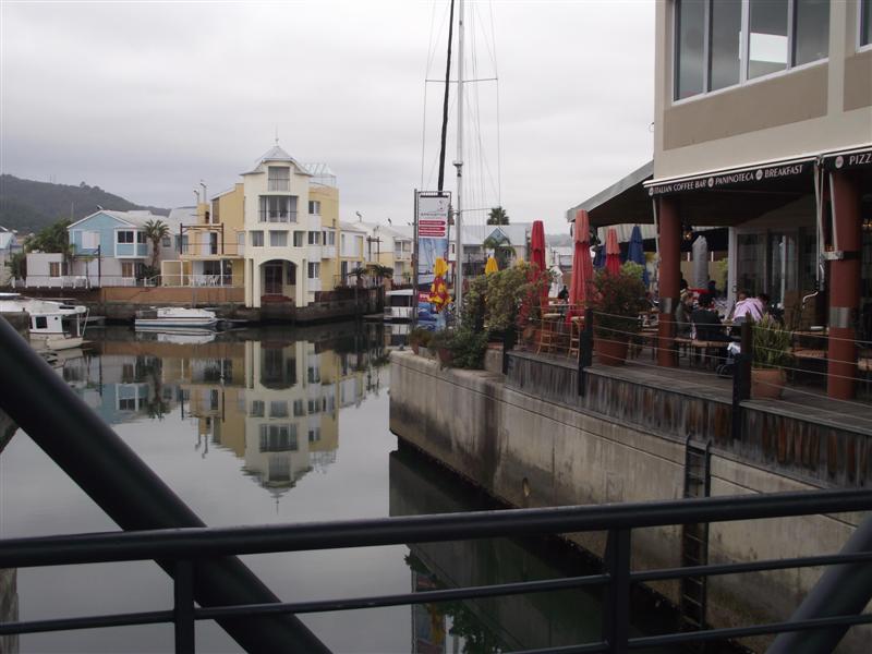
This guy was giving a display of utter motionless.
 However, he did lick his ice cream from time to time. The guy in front, though, did not move. I later thought he might be dead or something, but no medics arrived.
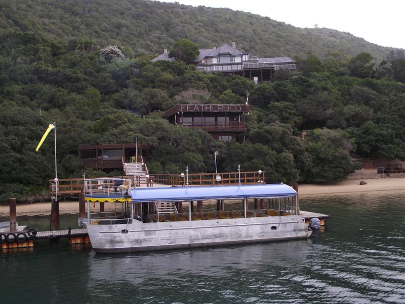
We then boarded the John Benn.
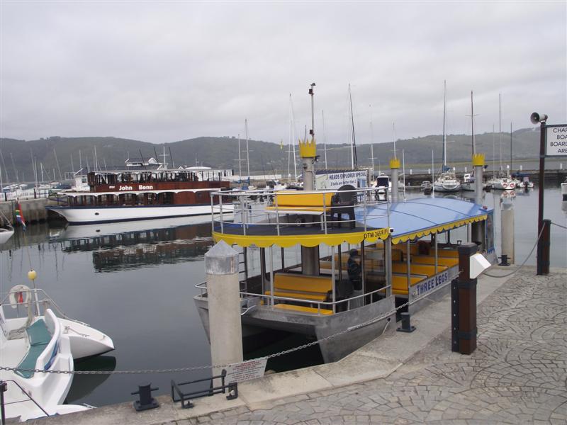
The John Benn is the one on the far side. It’s pretty much like a double decker pub.
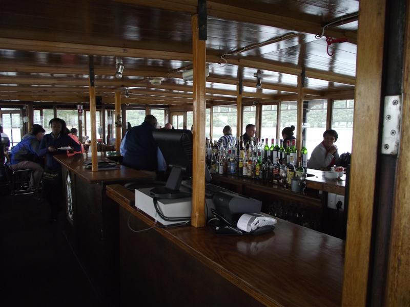
I reckon from a boating perspective it must also pretty much drive like a pub. The keel depth is half a meter, according to Cornelius who skippered the John Benn. Given the prevalence of the various sand banks, it is understandable.
The John Benn was clearly not built as a testament to speed and agility.
 [Source: Imagery ©2014 TerraMetrics, Map data ©2014 AfriGIS (Pty) Ltd, Google]
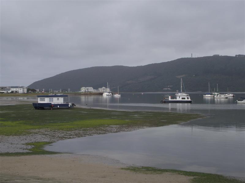
On the way to the Heads, you drive past the Featherbed restaurant. If you so wish, you can take the ferry destined for lunch at Featherbed. Apparently you also get a game drive included in the outing.
The Heads.
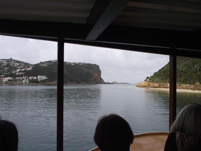

The weather on the day was a bit overcast, with a rather chilly wind blowing. In spite of that it was a very enjoyable outing. Next time we’ll try to include Featherbed in the itenary.
Tucson
Just for the petrol heads that might be reading here. The 2009 Tucson 2.0 GLS manual offers quite a bit of car for your money. I’m tempted to say its weight in gold, simply for the reason that this 2×4 SUV weighs in at 90 kilograms heavier than my double cab 4×4 Mazda bakkie.
The 2.0 GLS engine offers 104 kW (as opposed to the Mazda 3.4’s 108kW) but is geared differently. It feels vastly quicker and nippier than the Mazda, especially given the mass it needs to drag along.
The seven passes road we did we obviously did at a very leisurely pace, but the car handled the road with aplomb.
On the open road it can easily keep up with traffic. Although I prefer to drive at 110km/h, if need be the power is there to get you out of a tight spot.
Average fuel consumption over most of the trip was 11,2km/l. A strong headwind, and thereafter having a trailer full of wood hitched to the Tucson brought the fuel consumption down to just over 10km/l.
Rather splendid, I thought.
PG JONKER…
Cape West Coast
by PG Jonker
West Coast drive
April, the fairest of all months.
I know, the poem by C. Louis Leipoldt was about October being the fairest of all months. But Leipoldt did not live in post-1994 South Africa. More in particular, he did not experience the marvel of South African April with all its public holidays, interspersed by a working day here and there.
So making use of some of these holidays we went for a drive up the West Coast.

[Source: Map data ©2014 AfriGIS (Pty) Ltd, Google]
First stop the West Coast National Park at the Southern part of the Langebaan lagoon.

[Map from the SanParks brochure – see also www.sanparks.org].
As a National Park you need to pay the preservation fee if you don’t have the Wild Card. The Langebaan lagoon has fynbos, internationally acclaimed wetlands, and a wide variety of birdlife and antelopes.
At Kraalbaai, on the Western side of the lagoon, you find the Preekstoel (pulpit). According to the Sanparks brochure the firs Khoi dictionary of 400 words was documented here by De Flacourt, the Director General of the French East India Company in 1648.

Also some house boats and yachts.

When we were there it was low tide.

From there we drove to the southern tip of the lagoon. Geelbek is a restaurant inside the park. This was also in 1785 where the VOC in the Cape of Good Hope placed a beacon to demarcate it northern most boundary.

A boardwalk takes you to bird hides.

Bird species Curlow Sandpiper, Sanderling and Knot travels the 15000km’s from Northern Russia every year to breed here. Over 250 bird species are found here. This is more than a quarter of the total of South Africa’s bird species.
The birds don’t hide in the bird hide, though. We do.

The Langebaan lagoon was classified as a wetland of international importance under the Ramsar Convention criteria in 1975.

Unlike the beach at Kraalbaai, the bird hide did not exactly have the two twelve year olds with us thrilled. Admittedly, we were not there at a good bird spotting time, so we have not seen too many of the more than 250 species.
Shades of green:

Lunch at Driftwoods in Langebaan proved rather popular with all, though.

It was now becoming afternoon, and we first took a vote on whether we would still visit the West Coast Fossil Park. I was quite surprised at the two twelve year olds’ enthusiasm. Maybe they had grand visions of Jurassic Park.

We arrived at the Fossil park after the departure of the laste guided tour to the excavation site. The lady at the laboratory was kind enough, though, to give us a tour through the laboratory – which is where the guided tour in any event ends.

Some interesting facts we learnt were that this is one of the richest fossil sites in the world. It was discovered in 1930 when phosphate mining started there. Unfortunately a great many of the fossils had been destroyed in the mining operations. Apparently as much as 80% thereof. Nevertheless, more than a million specimens found its way to the Iziko museum in Cape town. After the mine closed in 1993 it was developed as a fossil park.
By the end of our tour even our Jurassic Park enthusiast’s concentration was starting to wear thin. After all, if the 5 million year old bone is actually solidified into stone, it cannot be cloned, and the DNA won’t exist to churn out a new African bear.

Last stop: Stompneus Bay.

It does not get better than this, huh?…
l’Agulhas

[Source: Map data ©2014 AfriGIS (Pty) Ltd, Google]
We left Cape Town on a chilly Saturday morning following a cold snap that left the mountains snow capped. It being a long weekend that already started on the Friday, we had the road for ourselves.
The Overberg has a good spread of the ordinary South African’s diet on the farm lands. Wheat, Canola and sheep. Bread, butter and lamb chops close at hand, thus.


From Caledon to Bredasdorp you have these rolling hills. Then, from Bredasdorp to Struisbaai and l’Agulhas you have this totally flat land. Due to recent heavy rains the roads were flooded because of the wetlands in the area.
The Agulhas light house is a very recognisable beacon. Now under construction.

The town itself is a pleasant dorp. A great many shipwrecks are found in the area.


The hallmark of the town is, apart from the lighthouse, the fact that it is the Southernmost tip of Africa.
In case you miss it:

A boardwalk guides you to the spot.

And wala!

Nature can cause one to be in a reflective mood.

If all fails, and you do get bored, there are, of course, other options.

The end of the weekend saw us heading back to Cape Town. It would seem that everyone has left Cape Town for the weekend. Which meant that everyone had to get back to Cape Town again.

Bumper to bumper traffic on Houwhoek pass and Sir Lowrey’s pass stretches the return trip of 220km’s to 4 hours.
Video clip.
Riebeek Vallei – Part 1
Riebeek-Wes
Some 80km’s from Cape Town lies the Riebeek Valley.

[Source: Map data ©2012 AfriGIS (Pty) Ltd, Google]
Travelling from Malmesbury you first get to Riebeek-Kasteel. Five kilometers further on you find Riebeek-Wes. It’s difficult figuring out why there are two towns, instead of one, given the demographics of the towns.
According to the 2001 census there were then 2532 people living in Riebeek Kasteel. The town itself is a wopping 1,4 square kilometers big. This, as opposed to Riebeek West, which only measures one square kilometer, and had 2661 residents in 2001. Which means that Riebeek-West is more densely populated, should you care to notice.
In spite of the name indicating the contrary, there is no castle in Riebeek-Kasteel (kasteel = castle). It would appear that the valley was found in 1661 by one of Jan van Riebeeck’s men, who then for lack of a better name called it Riebeek’s Castle.
Apparently the mountain looks like a castle. Maybe if you’re on the mountain, dude, but not from below! But then again, maybe one should give a bit of leeway for the views and needs of the settlers in those days. I guess a castle counted for something then, and you could hence easily mistake something for your dream castle. (I wonder what they smoked in those days?)
Rumour has it that some 24 000 people now stays in the Valley. I’ve got my doubts. On my first visit there I saw 13 people, which included 9 visitors. Admittedly, I was on the outer perimeter of Riebeek-Wes. On my second visit, though, I found myself in the hustle and bustle of down town Riebeek Kasteel. And indeed, this time I saw more people. About twenty people, but that was on a Sunday morning just as the church came out.
But these guys use any excuse for a festival. Maybe that’s when they get the 24000 people.
October – Shiraz & Arts Weekend
December – Kloovenburg Summer Market Day
March – Mediterranean Fest
April – Portuguese Festival
May – Olive Festival
July – Berg rivir marathon and the Riebeek Mountain Marathon
From the local information brochure I could glean that Riebeek-Kasteel sports 32 overnight places, and 12 eateries. Clearly, you might die of boredom long before you will die of hunger in this place. This outperforms Riebeek-Wes that only sports a humble 14 places to stay, and 3 eateries.
But according to my calculation it gives you an option of 46 places to stay, and 15 places to eat at. And that in two towns totalling 2,4 square kilometers. Not bad, huh?
For my first visit we went to stay at Andrea Townsend’s Church Hills Guest House in Riebeek-Wes. Andrea is a lawyer turned guest house owner who speaks Afrikaans, English and German. And a bit of French too, although most locals would probably mistake that for swearing.

A view from the stoep.


We went walkabout through Riebeek-Wes.


Time comes to a standstill.

But still takes its toll.

Each of these towns has its own church as well.

Roads are well marked. It’s only the Do-Do that has a bit of a problem knowing whether he should go left or right. No wonder he became extinct!

PGJ
…
Riebeek Vallei – Part 2
Riebeek-Kasteel
By the time you read here, you were supposed to have read my previous posting on Riebeek-Wes. So as not to repeat myself, most of the vital detail and statistics of the town are to be found in the previous mail.
After our first visit, and just to check that we have not missed something, we went back for a short visit to Riebeek-Kasteel.
And promptly tried out one of their restaurants. Kasteelberg Inn & Bistro. It was a coldish morning, with two fires being stoked to keep the place warm.

Behind the Inn you can see the outline of Kasteelberg (Castle Mountain). Of course it looks like a castle!
You could go next door for coffee.

Or we could also have eaten 20 meters away at De Jonges.

Or at Fat Cats Kitchen.

Or we might have been in a hurry.

Pizzas anyone? Bread? Cookies?

Or maybe just water?

Of course, there are other important things in life too.


And of course, the other hallmark of the Afrikaans platteland, the church.

And just as we left, I even noticed a few houses.

PGJ
…
Magic Klein Karoo
On a farm outside Montagu.
It is a mountainous area, with magnificent views.

Other things also amuses small minds.


Water is sourced from a natural spring. Pretty remote, and it takes some planning to get to the spring. So the farmer decided to make a road to get there.
Not quite your ordinary road. And albeit a road, it would be life threatening traversing it with a vehicle without low range.

The road takes you down into a ravine.
Here water comes from a rock. Unlike Moses there is no need to hit the rock. You just scrape away the moss, and out comes the water.

From there you walk a distance to get to the spring. Well, not really to the spring, but to a pool into which the spring deposits its water.
On your way there you find some interesting rock formations.

And more.

Looking back.

And then you find this pool between the rocks. At the far end where the water comes in, moss has made it a slippery slide. Once you let go, you have no control. Gravity takes over.

Careful, grandpa, let me hold your hand.

And then back up again.
 …
…
Tietiesbaai
By PG Jonker
[Published in Leisure Wheels, March 2011]
It’s always nice going back on your old tracks. One weekend we decide to follow my wife’s old tracks where they used to camp as kids at Tieties Bay. When they were small, long before the world discovered Tieties Bay, they used to camp there every summer holiday.
It is nice drive with the dirt road from Stompneus Bay to Paternoster. Paternoster used to be one of those secluded spots you would visit to get away from everyone. These days when you get there everyone is there already.
Downtown Paternoster is busy. Before you get the Paternoster hotel you drive past Oep vi Koep (Open for buy).

As expected, the local courtesy befalls us: any vehicle with a non-local registration number invariably gets an invitation along the lines of “Die Larnie willie ‘n kriefie koepie?” (Does the larnie want to buy a crayfish) Such a transactionwould, of course, be illegal. The appearance of a law enforcer evokes a quick recovery: “Nei, die Lanie niem net ‘n sneppie, nuh?” (No, the larnie is just taking a photo).
Downtown Paternoster is too busy for our liking. It is outside holiday season, so Tieties Bay should be deserted, guaranteed to render the expected splendour and quietness that we seek today.

Not so. Today Tieties Bay is just as busy as Paternoster itself. Some Inter Corporate Challenge sporting event is in full swing. Colour coded teams participate against each other. Rowing, cycling, that kind of stuff. We drive past all the action to where it is indeed quiet. We park the bakkie and walk off, away from the hustle and bustle.

My wife wants to go show me a cave where they used to play as kids. She relives the memories of big crayfish, waves and rocky pools to play in. She remembers this big pool where she used to swim as a four-year old. We find the pool. It is now 3 feet deep and 5 feet long. Maybe things look a bit bigger when you’re only 4 years old. My wife also shows me where the older girls would tan topless, and where the dudes would then peep over the rocks to watch the sun set.
Before we can reach the cave a guy with a huge camera comes running past us from behind. Then a whole team of participants in the Corporate Challenge also comes running past.

The next thing a chopper appears, with another camera man hanging out of the helicopter. Suddenly we find ourselves in something that feels like a reality show.

My cell pone rings. I answer, but cannot hear a thing. The rotor of the chopper makes one heck of a noise. Dust and foam from the water twirl up in the air.
Eventually things become quiet again. We reach the cave. The cave also turns out to be not as big as it used to be when my wife was 4 years old. In fact, it’s not really a cave, but rather a rocky overhang. Someone had a braai there recently. They did not clean up when they were done.
We can see that Jordan was there. As were Del and Carien. And Angel digs Reija, the grafitti on the rock confirms.
We sit down on a rock and enjoy the quiet.

Later we drive back. As one drive away from the sea you see the hill with the rock in the middle form which Tieties Bay got his name. It looks like a woman’s breast.

However, someone was not quite satisfied with mother nature’s endeavours, and decided to spice it up with something that makes the ‘nipple’ stand out more prominently.
Maybe it’s a good thing that the koppie was there before they built the lighthouse. The name might have been totally different then.

Paternoster’s beach remains a wonderful sight. 
Later the sporting event draws to a close on the beach, with flags, trucks, busses, sponsors’ advertisements, and plenty of people. A group of equestarians arrives from the opposite direction and meet up with there back-up team on the beach.
Paternoster has become a big town in comparison to what it used to be. It has become virtually impossible to take a picture without a “For Sale” bord somewhere in it. Guest houses abound.

I guess it’s progress. It’s good for the economy.
pgj
PG JONKER…
Beaverlac and Montagu
By PG Jonker
We had one of those extremely long weekends in May 2008. With a view on the upcoming tour to Vic Falls we were planning we decided it’s time for a trial run.
We were a party of three vehicles that hit the road to Beaverlac, just North East of Porterville. We took the back roads.

Just past (North of) Porterville is a worldwide renowned hang-gliding spot. For the benefit of the hang-gliders they tarred the little mountain pass.

It looks like nothing, but believe me it is nogal steep up there.
On top of the world.

In winter the land in the background become lush green wheat lands. Quite a sight then.
Some of the attractions at Beaverlac are the pools, and the foofy slide – hence the rope.

Of course we also did the camping thing, as was the purpose of the exercise.

At the fire:

We only stayed for one night, and thereafter left for Montagu. Due to a slight error in judgement we ventured into Montagu dorp on the Saturday morning.

Payday, Holiday, Easter, all compounded to make it a very busy morning.


At the end of the weekend we headed back home, and waited longer than a hour just to get through the Huguenot tunnel!
Nice weekend, though.
PGJ…